Predicting urban landslides in the hilly regions of Bangladesh leveraging a hybrid machine learning model and CMIP6 climate projections
Abstract
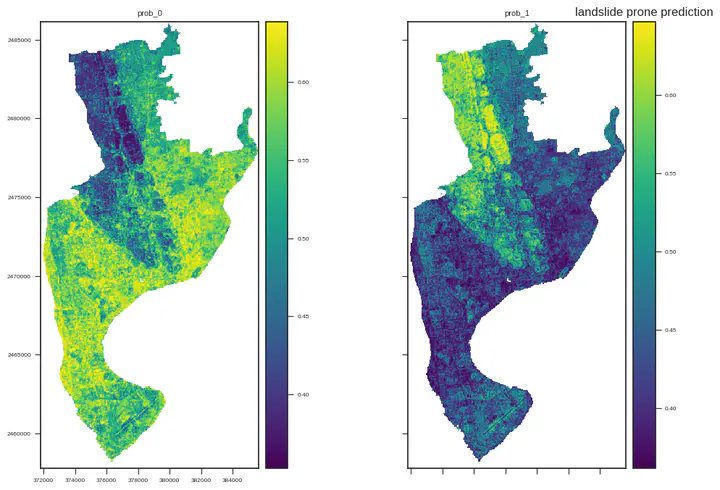
Landslides pose significant risks to infrastructure and human lives in cities, exacerbated by climate change. Therefore, a reliable predictive landslide model is crucial for mitigation, especially in resource-limited nations. This study employs advanced machine learning techniques and climate projections to predict landslides in the Chattogram development area (CDA) of Bangladesh – a rapidly growing urban area in Bangladesh. The model was trained using diverse geospatial parameters including topographic, hydrological, soil, and geological parameters, along with an updated landslide inventory, enabling spatially explicit predictions of landslide susceptibility. To incorporate future climate scenarios, we utilized the Coupled Model Intercomparison Project Phase 6 (CMIP6) Global Climate Model (GCM), projecting climate impacts under SSP126 and SSP585 scenarios for the periods of 2021-2040, 2041-2060, 2061-2080, and 2081-2100, respectively. These scenarios reflect different pathways of greenhouse gas emissions, providing a range of possible future climate conditions. We tested six machine learning classifiers: random forest (RF), extra trees (ExT), support vector machine (SVM), logistic regression (LR), Bernoulli Naïve Bayes (bNB), and K-nearest neighbor (KNN). Each base model demonstrated high accuracy (>90%) but combining them improved both accuracy and computational efficiency. The LR-bNB hybrid model outperformed all others, effectively mapping landslide susceptibility in the study area for the current timeframe and future projections. Our results revealed significant variability in landslide-prone areas across the area, with 12% of the region categorized as high to very high risk, a figure that slightly rises with predicted increased rainfall due to climate change. The present study demonstrates the efficacy of a hybrid ML model for nowcasting as well as forecasting landslide susceptibility under future climate scenarios. These findings offer valuable insights for proactive risk management and infrastructure planning in the Chattogram development area (CDA), helping to safeguard communities and improve resilience against future landslide events.
title: ‘Landslide susceptibilty mapping and prediction from satelite-imagery’
Authors
If you created a profile for a user (e.g. the default admin user), write the username (folder name) here
and it will be replaced with their full name and linked to their profile.
authors:
Author notes (optional)
author_notes:
- ‘Equal contribution’
- ‘Equal contribution’
date: ‘2023-09-08’ doi: ''
Schedule page publish date (NOT publication’s date).
publishDate: ''
Publication type.
Legend: 0 = Uncategorized; 1 = Conference paper; 2 = Journal article;
3 = Preprint / Working Paper; 4 = Report; 5 = Book; 6 = Book section;
7 = Thesis; 8 = Patent
publication_types: [‘3’]
Publication name and optional abbreviated publication name.
publication: # publication_short: #In ICW
abstract: ‘Landslide susceptibility mapping and prediction using satellite imagery involve the integration of various geospatial and environmental data to assess the likelihood of landslides in a particular area. We are developing AI driven methods to enable autonomous execution of landslide susceptibilty mapping in the hilly regions of Bangladesh’
Summary. An optional shortened abstract.
summary:
tags: []
Display this page in the Featured widget?
featured: true
Custom links (uncomment lines below)
links:
- name: Custom Link—
title: ‘Landslide susceptibilty mapping and prediction from satelite-imagery’
Authors
If you created a profile for a user (e.g. the default admin user), write the username (folder name) here
and it will be replaced with their full name and linked to their profile.
authors:
Author notes (optional)
author_notes:
- ‘Equal contribution’
- ‘Equal contribution’
date: ‘2023-09-08’ doi: ''
Schedule page publish date (NOT publication’s date).
publishDate: ''
Publication type.
Legend: 0 = Uncategorized; 1 = Conference paper; 2 = Journal article;
3 = Preprint / Working Paper; 4 = Report; 5 = Book; 6 = Book section;
7 = Thesis; 8 = Patent
publication_types: [‘3’]
Publication name and optional abbreviated publication name.
publication: # publication_short: #In ICW
abstract: ‘Landslide susceptibility mapping and prediction using satellite imagery involve the integration of various geospatial and environmental data to assess the likelihood of landslides in a particular area. We are developing AI driven methods to enable autonomous execution of landslide susceptibilty mapping in the hilly regions of Bangladesh’
Summary. An optional shortened abstract.
summary:
tags: []
Display this page in the Featured widget?
featured: true
Custom links (uncomment lines below)
links:
- name: Custom Link
url: http://example.org
url_pdf: ’' url_code: ’' url_dataset: ’' url_poster: ’' url_project: ’' url_slides: ’' url_source: ’' url_video: ''
Featured image
To use, add an image named featured.jpg/png to your page’s folder.
image: caption: ‘stomatal cell in stress condition’ focal_point: ’' preview_only: True
Associated Projects (optional).
Associate this publication with one or more of your projects.
Simply enter your project’s folder or file name without extension.
E.g. internal-project references content/project/internal-project/index.md.
Otherwise, set projects: [].
projects:
- example
Slides (optional).
Associate this publication with Markdown slides.
Simply enter your slide deck’s filename without extension.
E.g. slides: "example" references content/slides/example/index.md.
Otherwise, set slides: "".
slides: example
url: http://example.org
url_pdf: ’' url_code: ’' url_dataset: ’' url_poster: ’' url_project: ’' url_slides: ’' url_source: ’' url_video: ''
Featured image
To use, add an image named featured.jpg/png to your page’s folder.
image: caption: ‘stomatal cell in stress condition’ focal_point: ’' preview_only: True